This time round I think we can all rightfully use the term 'trek' for it was nothing short of that.
Sgtrekker's motto has always been: "Embracing the Adventure",
to which I would humbly add, especially for participants of this unforgettable trek: "Celebrating the Human Spirit".
Why, the audience may ask, do I add in the extra description?
Well, allow me to elaborate.
Like many other photography trips, some scheduled itineraries have gone a little off from what was originally planned, flights after flights (after flights) to the highly feared Lukla Airport have been delayed due to unforeseen weather conditions, contingency plans were activated, and destinations were re-designated on the ground at the 11th hour by the very capable Trek Leaders of SgTrekker - namely Adrian and Melvin.
Thus, the successful completion of this trek by all the participants was an epitome of the determination of the Trek Leaders in their strive to deliver their level best, as well as a true blue celebration of the insurmountability of each of the individual trekker's spirit in accomplishing what he or she has set out to.
Therefore, the success was nothing short of a celebration of the strength of the human spirit.
Introduction
A group of 24 of us joined Sgtrekker's Nepal Everest Trek from the 17th - 26th March 2011.
We came from very diversified backgrounds, of varying ages and were of very different levels of physical fitness.
SgTrekker has painstakingly emphasized and re-emphasized that this was NOT really a photography trip but was more of a trekking trip.
But I think no amount of pre-departure briefing, pre-pre departure briefing, pre-pre-pre departure briefing and pre-trek Bukit Timah Hill climbing organized by SgTrekker, could have effectively prepare us mentally for what we were eventually going to face.
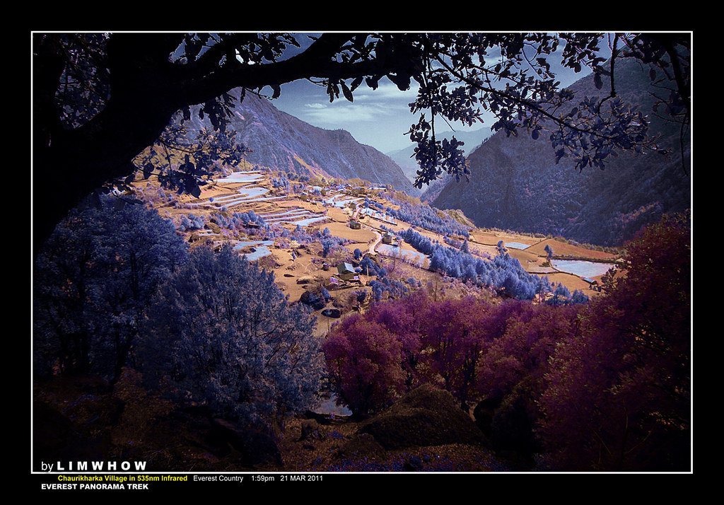
Before any of our audience go away with the notion that we all conquered Everest Base Camp (EBC) let me clarify that we did not. Our trek was taken along the exact trek towards EBC, and we ascended to Namche Bazaar which was 3440m above sea level.
The main objective of this assault was to originally fly in from Kathmandu to Lukla, the gateway town to EBC, and to trek over a period of 7 days to Namche Bazaar at 3440m, Tengboche at 3800m, and then trek back all the way to Lukla.
But as will be described later, bad weather conditions (which apparently were very common in the Himalaya ranges) delayed our domestic flights to Lukla, day after day, leaving us with only sufficient time to reach Namche Bazaar and to trek back to Lukla.
But SgTrekker made full use of our extra time in Kathmandu, and together with their local operators, brought us roaming deep into the streets of Kathmandu and showed us this ancient city in her most natural and jubilant character in the form of the Holi Festival, in addition to many other ancient sights of this historical city. Thus adding another colourful dimension to this very eventful trip.
If you want to skip the background info and jump straight into the ACTION, click below:
Everest Panorama Trek ~ Day 1. Singapore to Kathmandu, and Swayambunath Temple.
Nepal - Geography
Just a very brief introduction of Nepal to make the picture a little more complete.
Of course this accounts is by no means comprehensive but to set the stage for a little more understanding of this beautiful country as we all travelled upon this land.
To my fellow travellers, I personally know quite a few of you who have read extensively into the historical development of Nepal.
Thus I would be very grateful if you can add in more information along the way, and correct me in any factual mistakes that I would inadvertently commit.
Nepal has a population of 23 million, of which 1.5million living in Kathmandu.
It is a mountainous country with 64% of its area being mountains.
Geographically, Nepal appears like a rectangular-shaped land that stretches from north-west to south-east, sitting between Tibet on its northern border, with which it shares Mount Everest, and with India on its southern, western and eastern borders.
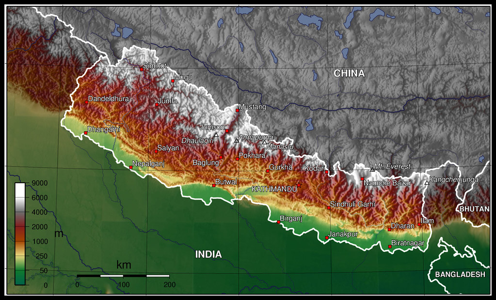
Map courtesy of Wikipedia Free Map.
The topographical characteristics of Nepal separates this land into the four main areas:
- The Terai - which is the real true flat plain in Nepal, in which half of its population resides.
- The Mahabharat, or also known as the Middle Hill region, that ranges from 1500m to 2700m.
- The Pahar region - which is that hilly stretch between the Mahabharat and the Himalaya. This is where Kathmandu and Pokhara are located.
- And of course, The Himalayan ranges, where 14 of the world's highest peaks are found. The well known ones, besides Everest, are Annapurna and Langtang, just to name a couple.
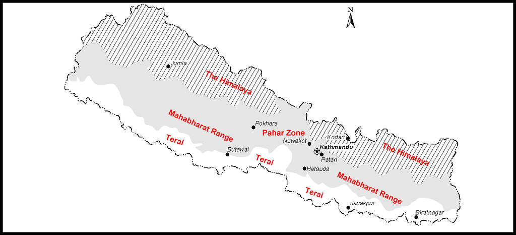
Map Courtesy of Wikipedia Free Map.
Nepal - Population
The Kathmandu Valley is where many historians would focus their attention in, for the rich, fertile soil of this expansive valley has given birth to many dynasty that gave Nepal its history.
There are 59 ethnic groups in Nepal, of which the Hindis (with their origin from the Aryans) comprise a majority, together with the other minorities, the more notable would of course be the most well-known Sherpas who inhabit the high mountain ranges, a Tibeto-Burma ethnic group who share very many similarities in culture and religion with their Tibetan cousins up north.
It would not be possible to mention all the other ethnic tribes of Nepal here in my this very brief account, but to just say that each of them contribute in their own ways to the cultural, religious and political development of the country.
It would however, not be far wrong to say that the main influence both in culture and religion came from India.
And like many Hindu society, the Caste system is still very much in play even in this present age.
Officially 80% of Nepalese are Hindus while 10% are Buddhist.
A Very Brief Historical Account
Like so many other lands caught in between warring tribes. Nepal has seen its own fair share of turbulence.
In the 7th centuty BC, the Mongoloid Hindu Kiratis people arrived from the east to become the first ruler of the Kathmandu valley.
In 300 AD (2nd century) the Licchavis arrived from northern India and overthrew the Kiratis, bringing with them an insurgence of Hiduism. The Licchavis left legacies of cultural brilliance as could be seen in the original stupas of Swayambhunath and Bodhnath.
In 1768, the Shah king Privthi Narayan Shah, who ruled the tiny Kingdom of Gorkha in between Kathmandu and Pokhara, invaded Kathmandu and ended the Malla dynasty.
He finally unified the whole of Nepal in 1769 after defeating the Malla Kings in Bhaktapur.
The Shah Kingdom expanded its territory from India to Sikkhim and on the western border to Kashmir.
In 1923, Nepal gained independence from the British and in 1930, the Kingdom of Gorkha was renamed The Kingdom of Nepal.
In 1950, the Shah King Tribhuvan did a self-exile to India while the newly formed Nepali Congress Party wrestled the power from the Rana family. With India's help, King Tribhuvan negotiated a deal with the Rana and returned to power in Nepal, and set up government with members of the Nepali Congress Party and demoted members of the Rana family.
In 2007, after massive protest, the King, Gyanendra, finally relinquished his political powers to a coalition government and Nepal officially became a Democratic country.
CLICK HERE BELOW TO GO TO THE NEXT CHAPTER:
Day 2 ~ Kathmandu welcomed us
No comments:
Post a Comment